
| Home | Communities | Accommodations | Places To Go | Things To Do | Site Map |
|
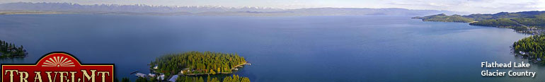
Glacier Country
Central Montana
Missouri River Country
Southwest Montana
Yellowstone Country
Southeast Montana
|
Name | City | ||
| Swinging Bridge Swinging Bridge Fishing Access Site is located 6 miles southwest of Columbus on Montana Highway 78, then 1 mile west on gravel road.... | Columbus | ||
| Table Rock Table Rock Fishing Access Site is located 8 miles south of Wolf Creek.... | Wolf Creek | ||
| Tarkio Tarkio Fishing Access Site is located west of Missoula off I-90 to Tarkio exit 61, south and east for 3/4 mile.... | Missoula | ||
| Tarkio East Tarkio East is located west of Missoula off I-90 or Exit 66, travel north, turn west on Frontage Road, follow to end of road and parking area.... | Missoula | ||
| Teakettle From Highway 93 north to the junction of Highway 40 just south of Whitefish, then east on Highway 40 to milepost 7 at Columbia Falls.... | Columbia Falls | ||
| Thibodeau Thibodeau Fishing Access Site is located 6 miles east of Johnsrud Fishing Access Site on the Corridor Road. The Johnsrud Fishing Access Site is 11 mi... | Missoula | ||
| Three Forks Ponds Three Forks Ponds Fishing Access Site is located immediately east of Three Forks.... | Three Forks | ||
| Tobacco Plains From Eureka, turn south on US Highway 37 and travel for approximately 2.5 miles to the Sophie Lake/Tetrault Lake road. Turn north onto this road and ... | Rexford | ||
 | Tom Jenni's Reel Montana Please call for directions.... | Bozeman | |
| Triangle Pond From Noxon, turn west onto Road 2229 (also known as the Noxon-Heron road) and follow for 3.5 miles to the site. Triangle Pond is adjacent to the rail... | Noxon | ||
| Trout Pond (Dredge Cut) Trout Pond is located 3 miles north of Fort Peck on Montana Highway 117.... | Fort Peck | ||
| Truly Take-Out Truly Take-Out Fishing Access Site is located 8 miles southeast of Ulm.... | Ulm | ||
| Tucker Crossing Tucker Crossing Fishing Access is located 3 miles south of Victor on Highway 93.... | Victor | ||
| Turah Turah Fishing Access Site is located 6 miles east of Missoula on I-90 to milepost 113, then 2 miles southeast on County Road.... | Missoula | ||
| Twelve Mile Dam Twelve Mile Dam is located 11 miles south of Miles City on Highway 59, then 1 mile south on the Tongue River Road, Highway 332.... | Miles City | ||
| Two Leggins Located 8 miles south of Hardin, Montana on Secondary Road 313, at Two Leggins Bridge.... | Hardin | ||
| Ulm Bridge Ulm Bridge Fishing Access Site is located 1/2 mile southeast of Ulm.... | Ulm | ||
 | Upper Carter Pond Upper Carter Pond Fishing Access Site that is located 11 miles northeast of Lewistown.... | Lewistown | |
| Valley Garden Valley Garden Fishing Access Site can be located on US Highway 287, 1/4 mile south of Ennis to milepost 48, then 2 miles north on County Road.... | Ennis | ||
| Varney Bridge Varney Bridge Fishing Access Site is located 1 mile west of Ennis on US Highway 287, then 10 miles south on County Road.... | Ennis | ||
| <-- Previous | Next --> | ||
A source for Montana Travel & Tourism Information
![]()