
| Home | Communities | Accommodations | Places To Go | Things To Do | Site Map |
|
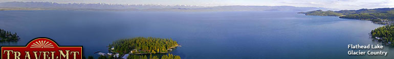
Glacier Country
Central Montana
Missouri River Country
Southwest Montana
Yellowstone Country
Southeast Montana
|
Name | City | ||
| Hellgate Canyon Trail The trail begins on the River Trail by the University. Up river about a mile, there's the Hellgate Canyon Trail sign. Here it climbs the north side ... | Missoula | ||
| Hellroaring Creek Trail-NPS The Hellroaring Creek Trail travels from the Mammoth-Tower Road to the park's north boundary, and continues into the Gallatin National Forest. The He... | Yellowstone National Park | ||
| Hellroaring Plateau Trail The trailhead is near the top of a winding mountain road, beyond Parkside campground. The campground is located 12 miles southwest of Red Lodge on U... | Red Lodge | ||
| Hellroaring Snowmobile Area Travel 30 miles northeast of Troy on FDR 92 to Road 524. Turn and follow 0.5 mile, turning onto Road 745. Follow to a gate, which is the beginning o... | Troy | ||
| Henderson Mountain Snowmobile Trail Henderson Mountain Snowmobile Trail is located out of Cooke City.... | Cooke City | ||
| Hendrickson Gulch Trail From Superior, take the south side Road 69 west for 13.5 miles to Cold Creek Road 3803. Proceed 9.3 miles to Road 4206. Go approximately 500 feet to... | Superior | ||
| Henry Lakes Trail From Troy, travel northeast 59 miles on FDR 92. Turn south on Road 6035 and follow for approximately 2.5 miles to the junction with Road 6034. Turn ... | Libby | ||
| Hidden Basin Wildflower Trail The trail is located north of Crystal Lake and can be accessed from the Crystal Lake Shoreline Loop Trail. Call for directions.... | Stanford | ||
| Hidden Lake Trail Travel east from Townsend on US Highway 12 approximately 2 miles, then north on State Highway 2184 approximately 10 miles to Duck Creek Road (Forest R... | Helena | ||
| Hidden Lake Trail The Hidden Lake Overlook Trail begins behind the Visitor Center at Logan Pass.... | Glacier National Park | ||
| Highline Trail From Fortine, travel north 3 miles on US Highway 93. Turn onto Grave Creek Road 114 and follow for 10 miles to Clarence Road 7022. Turn north and tr... | Fortine | ||
 | Highline Trail Highline Trail begins at the Continental Divide sign at Logan Pass.... | Glacier National Park | |
| Highwood Environmental Trail Located 6 miles east of Great Falls on US Highway 89. Turn north on Montana Highway 228 and travel 13 miles to major junction. Cross the junction, a... | Great Falls | ||
| Hiline Trail #111 From Philipsburg go south on Highway 1 for 6.4 miles, than west on Highway 38 for 9 miles, than south on Road 5106 for 15 miles to the Middle Fork Tra... | Philipsburg | ||
| Himes Spring Creek Trail #343 Travel 33 miles south of Libby on US Highway 2. Turn right onto Silver Butte Road 148 and travel 3.5 miles to East Fisher Road 154. Proceed 4.3 mile... | Libby | ||
| History Rock Trail ... | Bozeman | ||
| Hobnail Tom Trail Take Highway 200 6 miles east of Ovando to junction of northfork of the Blackfoot Road 5550. Follow signs and Road 5550 to the trailhead. Non-motori... | Seeley Lake | ||
| Hole In The Wall Campground Trail Hole in the Wall trail is a short spur trail off of the Boulder Pass trail at 16.6km. The trail leads to a back country campsite .Trail Beginning: B... | Glacier National Park | ||
 | Holland Falls Nature Trail ... | Bigfork | |
| Holland Lake Snowmobile Trail Holland Lake Snowmobile Trail is located out of Seeley Lake.... | Seeley Lake | ||
| <-- Previous | Next --> | ||
A source for Montana Travel & Tourism Information
![]()