
| Home | Communities | Accommodations | Places To Go | Things To Do | Site Map |
|
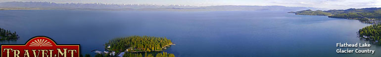
Glacier Country
Central Montana
Missouri River Country
Southwest Montana
Yellowstone Country
Southeast Montana
|
Name | City | ||
| Knife Point Trail From Highway 37, cross Koocanusa Bridge (15 miles south of Eureka) and proceed south on FDR 228 for 8 miles to the Junction with Big Creek Road 336. ... | Eureka | ||
| Knox Creek Trail The trailhead is signed off of the Thompson-Henderson Road, Forest Road 352, approximately 5 miles south of Thompson Falls, Montana. Recommend acquiri... | Plains | ||
| Kootenai Creek Trail From the Stevensville junction on Higway 93, travel north 1 mile, turn west on Kootenai Creek Road, proceed 2 miles to the trailhead.... | Stevensville | ||
| Kootenai Creek Trail From Troy, travel east 6 miles on US Highway 2.... | Libby | ||
| Kreis Pond Mountain Bike Trails You can get a brochure and direction at the Ninemile Ranger Station. Exit 82 from Interstate 90 and go north. Follow signs to the Ranger Station.... | Huson | ||
| Krinklehorn Peak Trail From Fortine, travel north 3 miles on US Highway 93. Turn onto Grave Creek Road 114 and follow 3 miles to Stoken Road 7061. Turn right and follow ab... | Fortine | ||
| Krinklehorn-Locke Mountain Trail From Fortine, travel north 3 miles on US Highway 93. Turn onto Grave Creek Road 114 and travel for 3 miles. Turn onto Stoken Road 7061, follow for 2... | Fortine | ||
| Lake Columbine Trail Lake Columbine Trail is located 25 miles south of Big Timber on Highway 298, then 23 miles south on County Road 212. Connects to Rainbow Creek trail.... | Big Timber | ||
| Lake Como National Recreational Loop Trail Travel 4 miles north of Darby on US Highway 93, then go 5.3 miles on County Road 82.... | Darby | ||
| Lake Elsina Snowmobile Trail Lake Elsina Snowmobile Trail is located out of Seeley Lake.... | Seeley Lake | ||
| Lake Fork Ski Trail Located 10 miles south of Red Lodge on Highway 212.... | Red Lodge | ||
| Lake Isabel Trail Lake Isabel can be accessed by hiking the trail departing from the north end of the Walton Ranger Station complex, which is located on US Highway 2 at... | Glacier National Park | ||
| Lake Louise Trail From Interstate 90 take Cardwell exit 7 miles east of Whitehall. Take Montana Highway 359 south for approximately 5 miles to South Boulder Road 107. ... | Whitehall | ||
| Lake Marshall Loop Snowmobile Trail Lake Marshall Loop Snowmobile Trail is located out of Seeley Lake.... | Seeley Lake | ||
| Lake Marshall Snowmobile Trail Lake Marshall Snowmobile Trail is located out of Seeley Lake.... | Seeley Lake | ||
| Lake McDonald Ranger Station Trail The Lake McDonald Ranger Station is located at Fish Creek Campground or 2.8 miles west on North Lake McDonald Road, and then two miles to Kelly Camp. ... | Glacier National Park | ||
| Lake Mountain Trail Take Highway 200 to the Northfork of the Blackfoot Road. At the trailhead look for the Lake Montana Trail sign.... | Seeley Lake | ||
| Lake Otatsy Trail Take Highway 200 to the Northfork of the Blackfoot Road. Approximately 0.5 mile from trailhead is the Junction of Trail 61.... | Seeley Lake | ||
| Lamar Slough Creek Trail The Slough Creek Trail starts from the gravel road leading to Slough Creek Campground (10 miles east of Tower Junction), and is reached about 1/2 mile... | Yellowstone National Park | ||
| LaMarche Creek Ski Trail Located 16.5 miles west on Highway 43, 3.5 miles north on Road 935. Go through Sundance Lodge Gate 0.25 mile to trailhead.... | Wise River | ||
| <-- Previous | Next --> | ||
A source for Montana Travel & Tourism Information
![]()