
| Home | Communities | Accommodations | Places To Go | Things To Do | Site Map |
|
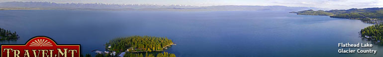
Glacier Country
Central Montana
Missouri River Country
Southwest Montana
Yellowstone Country
Southeast Montana
|
Name | City | ||
| Bainville United Methodist Church Bainville United Methodist Church is located off Highway 2, cross railroad tracks, go four blocks south, turn right, four blocks west. Bainville is 8... | Bainville | ||
| Baker Chamber of Commerce ... | Baker | ||
| Baker Community United Church of Christ To find the Baker Community United Church Of Christ from Highway 12. Go to 1st Street West (one block west of intersection of Highways 7 & 12), turn s... | Baker | ||
| Baker Lake Trail Travel 4 miles south of Darby take the West Fork Road 473 for 7 miles to the Baker Lake Road 363. Go to the fork in the road and take Road 5634 to th... | Darby | ||
| Baker Street Bistro Baker Street Bistro is located in Whitefish on your way to the ski area, just before you head over the viaduct on your left.... | Whitefish | ||
 | Baker's Hole Campground Baker's Hole is located 3 miles north of West Yellowstone on US Highway 191.... | West Yellowstone | |
| Bald Hills Trail Located 20.6 miles southwest on Forest Road 839 to Forest Road 268, then 6 miles on Forest Road 268 to the end of road. The trailhead is ROG 59.... | White Sulphur Springs | ||
| Baldy Lookout Trail Trailhead is located approximately 15 miles north of Plains, Montana. via the Upper Lynch Creek Road, and Forest Roads 1025 and 886.... | Plains | ||
| Bales Hunts Please call for place to meet.... | Otter | ||
| Ballantine Sts. Cyril & Methodius Ballantine Sts. Cyril & Methodius/Catholic can be found by taking the Ballantine exit off interstate.... | Ballantine | ||
 | Balloons Over Bozeman Balloons Over Bozeman flights originate within a few miles of downtown Bozeman, Montana, but launch sites vary according to weather patterns. We will... | Bozeman | |
| Balsinger Trail Located 19.1 miles northwest of Kings Hill on Forest Road 839. The trailhead is ROG location 61.... | White Sulphur Springs | ||
| Bambu Bar and Asian Bistro Bambu Bar & Asian Bistro is located in the Big Sky Mountain Village, on the 3rd floor of the Arrowhead Mall (next to the Summit Hotel). Incredible vi... | Big Sky | ||
| Bangtail Trail (Grassy Mountain) ... | Bozeman | ||
| Banjos Club 109 Banjos Club 109 is located in Scobey at 109 Main Street. Scobey is located in northeast Montana on Highway 12 approximately 50 miles north of Wolf Po... | Scobey | ||
| Bank of Baker Our financial institution is located one block south of the intersection of Highway 7 North and Highway 12. The facility is next to Baker Lake.... | Baker | ||
 | Bannack State Park Bannack State Park is located in the southwestern area of Montana. Take I-15 south of Dillon to exit #59 (Highway 278 exit.) Drive west on Highway 2... | Bannack | |
 | Bannock Pass Ranch To reach Bannock Pass Ranch from I-15 north or south take the Clark Canyon Dam Exit #44 and follow Highway 324 south west for approximately 30 miles. ... | Dillon | |
| Bannock Ski and Snowmobile Trail The trail is located between Cooke City and Silver Gate.... | Cooke City | ||
| Baptiste Lookout Trail Access from Martin City, drive south on the east side of the reservoir for about 37 miles, turn east on Logan Creek Road 1632, stay to the right at th... | Hungry Horse | ||
| <-- Previous | Next --> | ||
A source for Montana Travel & Tourism Information
![]()