
| Home | Communities | Accommodations | Places To Go | Things To Do | Site Map |
|
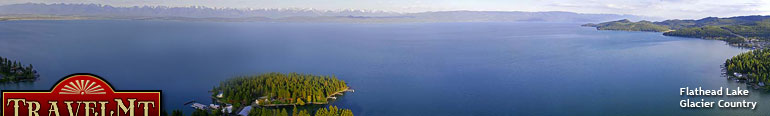
Glacier Country
Central Montana
Missouri River Country
Southwest Montana
Yellowstone Country
Southeast Montana
|
Name | City | ||
| Center Ridge Trail From Highway 200 take the Monture Creek Road to the Guard Station. From there take the trail straight up the ridge above the Guard Station.... | Seeley Lake | ||
| Cherry Creek Trail Travel 1.5 miles west of Melrose on Trapper Creek Road 188, 8.7 miles west on Cherry Creek Road 1011. The trailhead is at the end of the Cherry Creek... | Wise River | ||
| Chief Joseph Cross Country Ski Trail Chief Joseph Cross Country Ski Trail is located on the continental divide on the western Montana border about 40 miles south of Hamilton and 100 miles... | Sula | ||
| Chub Creek Trail Travel 11 miles west of Wise River on Highway 43, then take Anaconda Road 274 north for 4 miles, then take Seymour Creek 934 northwest for 8 miles.... | Wise River | ||
| CL Ranch Cross-Country Ski Trail The CL Ranch is about eight miles northeast of Clyde Park. Take US Highway 89 north through Clyde Park. About a mile north of town, turn east on Cot... | Wilsall | ||
| Clarence-Rich Creek Trail From Fortine, travel north 3 miles on US Highway 93. Turn right onto Grave Creek Road 114 and travel 8 miles to Junction with Road 7021. Turn here a... | Fortine | ||
| Clary Coulee Trail Take Highway 89 from Choteau 5 miles, turning west on Teton River Road 144. Follow the road 22 miles to Clary Coulee Trail, 1 mile past the Cow Track... | Choteau | ||
| Clear Lake Trail From I-90 take the Two Mile Exchange at Exit 30. Go south on Two Mile Creek Road 431 to Newman Ridge Road, 1185. Go southwest 11.6 miles to the Stat... | Superior | ||
| Clearwater Canoe Trail From Seeley Lake, drive 4 miles north on Montana Highway 83. Turn west at the Clearwater Canoe Trail sign and proceed 0.5 mile to the put-in. The c... | Seeley Lake | ||
| Cliff and Wade Lakes Interpretive Trail Follow US Highway 287 about 40 miles south from Ennis. Turn right at the sign for Cliff and Wade Lakes. Continue down the dirt road for about 6 mile... | Ennis | ||
 | Cliff Point Trail From Rexford, South 7 miles on Highway 37 to Koocanusa Bridge. Cross the bridge and travel South on FDR 228 for 4.8 miles to Junction with the lower ... | Eureka | |
| Coal Creek Ridge Trail Check with the Hungry Horse or Glacier View Ranger District.... | Hungry Horse | ||
| Coal Creek Trail The Coal Creek Trail is accessed from Highway 2 east of West Glacier. Information can be obtained at the Apgar Visitor Center.... | Glacier National Park | ||
| Columbia Mountain Loop Trail Follow the signs on Highway 2, northeast of Columbia Falls, to the trailhead on the northwest side of Columbia Mountain at the north end of Berne Road... | Hungry Horse | ||
| Confluence Trail Confluence Trail is located in the Missouri Headwaters State Park. Three miles east of Three Forks on I-90 at Three Forks exit, then east on Secondar... | Three Forks | ||
| Conger Creek Trail See Lolo East Map. This trail takes off of the Lake Otatsy trail from the North Fork Trailhead.... | Seeley Lake | ||
| Conger Point Trail From the Norhtfork Trailhead north of Highway 200 take the Otatsy Lake trail north. The Conger Peak and Creek Trails start at Camp Pass and Canyon La... | Seeley Lake | ||
 | Continental Divide National Scenic Trail Trailhead may be best accessed at Red Rock Pass on the gravelled Red Rock Pass Road from Highway 20, south of Henry's Lake in Idaho.... | Dillon | |
| Continental Divide National Scenic Trail The trail can be accessed off main travel routes at the following mountain passes: MacDonald, Rogers, Flesher, Stemple, and Priest.... | Helena | ||
| Continental Divide National Scenic Trail 9 Please call Sula Ranger District for directions and information.... | Sula | ||
| <-- Previous | Next --> | ||
A source for Montana Travel & Tourism Information
![]()