
| Home | Communities | Accommodations | Places To Go | Things To Do | Site Map |
|
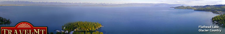
Glacier Country
Central Montana
Missouri River Country
Southwest Montana
Yellowstone Country
Southeast Montana
|
Name | City | ||
| Davis Mountain Trail From Trego, travel southwest 8 miles on Road 36 to the junction with Road 48. Turn and travel for 3.5 miles, turning left onto Road 7156. This road ... | Fortine | ||
| Dawson Pass Trail The Dawson Pass Trail can be accessed by starting at the Two Medicine north shore trailhead. Trail follows the north side of Two Medicine Campground.... | Glacier National Park | ||
| Dead Dog Loop Ski Trail Located out of West Yellowstone; access by Rendezvous Ski Complex.... | West Yellowstone | ||
| Deadman Ski Trail 7 miles southeast of Neihart. Park just off Highway 89 at Kings Hill Campground Trailhead east side of the highway.... | Neihart | ||
| Deep Creek Ridge Trail Travel 1.6 miles west on Forest Road 268 from junction of Forest Roads 839 and 268 to Trail 339. Then travel north 1.1 miles on Trail 339 to 338. Th... | White Sulphur Springs | ||
| Deep Creek Ski Trail Follow US Highway 93 to Deep Creek Road 368, about 39 miles north of Whitefish and 15 miles south of Eureka. Turn right and follow Deep Creek road fo... | Fortine | ||
| Deep Creek Trail Located 2.7 miles south of Logging Creek Campground on Forest Road 830 to Mill Creek. The trailhead is ROG route location 54.6... | White Sulphur Springs | ||
| Deep Creek Trail From Fortine, travel US Highway 93 to Deep Creek Road 368. Turn and follow 1.2 miles, then turn left onto Road 368. Travel 5.5 miles, turning left b... | Fortine | ||
| Demers Ridge Trail ... | Hungry Horse | ||
| Derby Mountain Trail Derby Ridge Trail starts at West Bridger Cabin, approximately 27 miles southeast of Big Timber on I-90, Bridge Creek Road, then 2 miles on West Bridge... | Big Timber | ||
 | Dickey Lake Accessible Trail From Murphy Lake Ranger Station, south 2.1 miles on US Highway 93. It is located 0.1 mile off the highway.... | Fortine | |
| Dickey Lake-Mt. Marston Trail From Fortine, travel south 6 miles on US Highway 93. Park at the Trego turnoff and hike for 0.25 mile. The trail sign and trailhead are on the west ... | Fortine | ||
| Dinah Lake Trail Take Highway 83 north past Seeley Lake, turn left on the Boy Scout Road. From here you'll need the Lolo West map of the Seeley Lake District.... | Seeley Lake | ||
| Discovery Basin Ski Trails From Philipsburg go south on Montana Highway 1 for 12.4 miles to the Echo Lake Road 65. Following signs to Discovery Basin Ski Area, go 4.6 miles. T... | Philipsburg | ||
| Divide Creek Trail The Divide Creek Trail can be accessed from Red Eagle.... | Glacier National Park | ||
| Divide Creek Trail Travel 45 miles south on Ruby River Road 100, then 1 mile west on Divide Creek Road.... | Sheridan | ||
| Divide Trail Travel 12 miles northeast of Libby on Highway 37. Turn right onto Road 534 and travel 9 miles to the junction with Road 535. Follow 1.5 miles and tu... | Libby | ||
| Doe/Buck Creek Snowmobile Trail Doe/Buck Creek Snowmobile Trail is located 48 miles southwest of Bozeman.... | Bozeman | ||
| Dome Shaped Mountain Trail #8 From Philipsburg go north on Highway 1 for 0.2 miles, than west on County Road 348 for 12.5 miles, than west on County Road 102 for 4.6 miles, than so... | Philipsburg | ||
| Dominion Peak Trail From I-90 take the Saltese Exit 10. Go south on Silver Creek Road 305. The trialhead is 1 mile ahead on the right.... | Superior | ||
| <-- Previous | Next --> | ||
A source for Montana Travel & Tourism Information
![]()